Metro Train Route Plan in Ahmedabad - Latest New Metro Rail Project Map in Ahmedabad
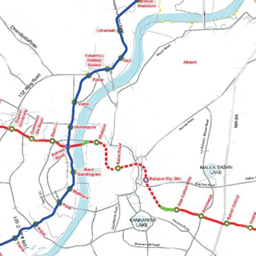
First phase of the Ahmedabad Metro project will span approximately 34 km and comprise two corridors. The north-south corridor will connect Motera and APMC, and the east-west corridor will connect Thaltej and Vastral village. Both corridors will meet at Ashram Road.
The total length of the route is 35.2km (approx) which include 28.2 km elevated and 7.0 km underground section having 32 stations along with Metro Rail Route Map Ahmedabad. Chief Minister Anandiben Patel has cleared the new plan of Metro Train Route Map in Ahmedabad, including stations at APMC, Vejalpur, Shreyas Crossing, Parimal underpass, Gandhigram, Old Court and Nava Vadaj.
Anandiben Patel Design Metro Rail Route has been done in a way that gives easy access to Commuters from both eastern and Western Side. New Areas of Metro Train in Ahmedabad like Shyamal Cross Roads, Bhudarpura, Manekbaug and Satellite will get the benefits.
According to the New Route of Metro Train Plan in Ahmedabad, the Metro will not go to Ahmedabad airport in the first phase. Likewise, areas such as Parimal Garden and Panjrapol in west Ahmedabad, and Danilimda, Asarwa, Isanpur and Ghodasar in east Ahmedabad, which were originally planned to be covered by Metro, also do not find a place in the New Route of Metro Rail Project. The Metro project was originally planned to connect Ahmedabad and Gandhinagar. However, the government has decided to against extending the project to Gandhinagar in view of insufficient traffic availability
|


.png)