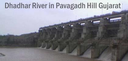
Dhadhar River in Pavagadh Hill Gujarat - Dhadhar River Basin History Details and Photos
Dhadhar River is a river located on the west part of Gujarat State. Dhadhar river begin from Pavagadh Hills and flows through Vadodara & Bharuch. The total length of it is 142 km. The area surrounded by it is 4,201 sq. km. The other names of the Dhadhar River are Dhadhar Nadi and Dhadhar. It is situated at the height of 85 metre above sea level.
After flowing 87 kms it meets Vishwamitri tributary from the bank Pingalwada village 500m and meets other rivers. It meets Gulf of Khambat after flowing more new 55 kms. The main important tributaries of the Dhadhar River are Dev, Surya, Vishwamitri, Deo and Jambuo Rivers. The Dhadhar Rivers lies among east longitude 72⁰30⁰ and 73⁰ 45⁰ and north longitude 21⁰ 45⁰ and 22⁰ 45⁰ latitude. Deo dam is situated at the distance of 26 km and area of it is 259 Sq.km.
The Dhadhar Basin receives more water during rainy fall from the south-west side in June and September. The climate of the river is hottest in the June, Coldest in January and Humid in August. There are different types of industries near the Dhadhar River they are Rubber & Plastic, Tobacco products, Spinning textile, Machinery and Vehicle parts, Electrical Machinery and Chemical Petrolium products.
The cities located near the river are Vadodara, Karjan, Baroda, Nadiad, Jambusar, Amod and Pinjalwada.
The view of the Dhadhar River Basin in the rainy season is very much beautiful because the flow of the water is more. |
